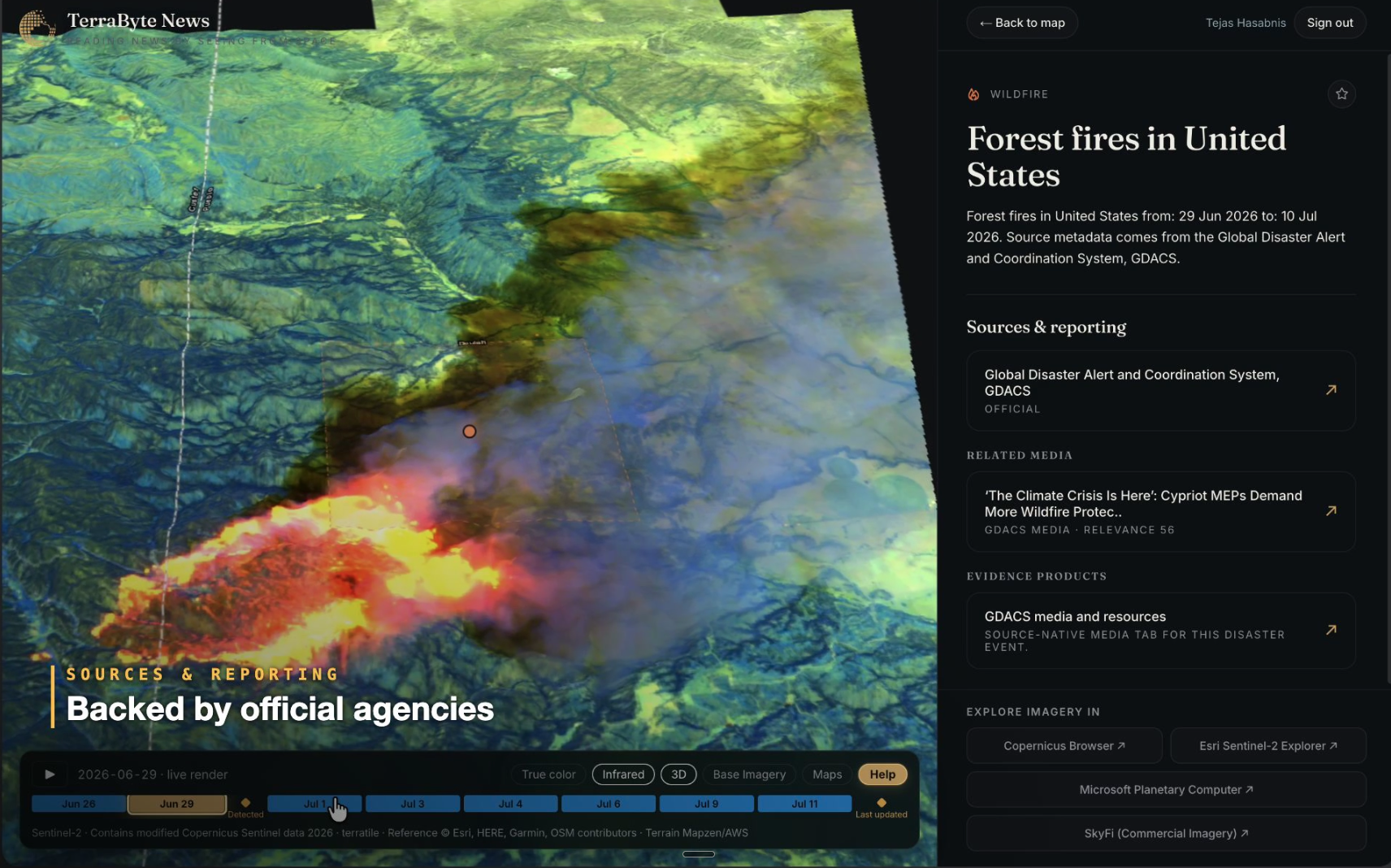
TerraByte News is a free live map that shows the most recent satellite imagery over every active wildfire, earthquake, cyclone, and severe weather event. TerraByte built it because a news report tells you what happened somewhere, and during a disaster the question people actually ask is where it is happening relative to them.
What question does TerraByte News answer?
"How close is it to me?"
In July 2026, TerraByte CEO Rishi Madhok's brother was living a few miles from the Little Fire, a roughly 1,000 acre wildfire south of Pleasanton, California, near Sunol. He texted the question everyone texts during a wildfire: do I need to worry?
The coverage available at the time offered a helicopter photo, an acreage figure, and a containment percentage that was already going stale. None of it answered what he was actually asking, which was where the fire sat relative to his street.
TerraByte News answered it in about 30 seconds. The Little Fire was already on the map, streaming from the CAL FIRE incident feed. One click opened the most recent satellite pass over the burn. Switching to infrared lit up the burn scar, the exact footprint of what had burned rather than a description of it. Scrubbing the timeline backward showed which direction the fire had moved and how fast.
He was fine. The spread stopped, evacuations lifted, no homes lost. But the gap that text message exposed is the reason TerraByte News exists. Satellites see almost every major fire within hours. The people who need to act on that imagery mostly cannot read it, cannot find it, and do not know it is free.
How does TerraByte News work?
TerraByte News joins two things that normally live in different systems: authoritative event alerts and current Earth observation imagery. The map is the join.
| Layer | What it contributes | Sources |
|---|---|---|
| Event feeds | Where something is happening, and what kind of event it is | CAL FIRE incident feed, NASA FIRMS active fire detections, NOAA National Weather Service and National Hurricane Center |
| Satellite imagery | What the place looks like right now | NASA GIBS, Sentinel, NOAA/NESDIS, EUMETSAT, Himawari-9, GK-2A |
| Basemap | Geographic context under the event | Esri, Maxar, Earthstar Geographics |
| High resolution on request | Sharper and newer imagery you can buy directly | SkyFi, drawing on more than 300 sources, from $15 per image |
None of the underlying imagery belongs to TerraByte. Public agencies have been giving it away for years. What TerraByte built is the place where an event, its location, and the imagery over it sit together in one view, so that finding them does not require GIS software, a coordinate, or knowing which agency publishes what.
The SkyFi partnership, announced in July 2026, closes the last step. When the free public imagery is not sharp enough or not recent enough, you can order a higher resolution image of the same area without leaving the workflow.
What can you do on TerraByte News?
- Search by event type. Keyword search covers wildfire, earthquake, cyclone, and severe weather.
- Find what is near you. The Nearby view sorts active events by distance and widens its radius automatically, from 25 km out to 100 km, when nothing is close.
- Open the latest satellite pass. Every event card marked SAT has imagery attached, dated, and one click away.
- Switch to infrared. Burn scars, heat signatures, and smoke separate cleanly from terrain in infrared in a way they do not in true color.
- Scrub the timeline. Move backward through captures to see how a fire, flood, or storm actually moved rather than reading a summary of it.
- Read the Daily Digest. A running feed of what is currently active, ordered by proximity and recency.
TerraByte News is free to use and requires no account.
How is TerraByte News different from a wildfire tracker or a news feed?
Most tools in this space do one of three things well. TerraByte News does the third.
- Alerting tools tell you that something is happening and what to do about it. Watch Duty is the best example, and during an active fire it is the app that belongs on your phone. It gives you the evacuation orders, the alerts, and the hotspots, maintained by people doing hard human work. TerraByte does not replace it.
- News coverage explains an event after reporters have confirmed it. Accurate, but describing a situation that has usually already changed.
- Imagery archives hold the actual pictures. NASA, ESA, and NOAA publish enormous volumes of imagery for free. Almost nobody outside the remote sensing industry can locate a specific scene in them or read it once found.
TerraByte News sits in the third category and adds the picture underneath the alert. During the Spokane fires in early August 2026, three separate fires burned around the city, each with its own incident record and its own feed. A fire does not come from one direction, and nobody evacuates by incident number. People evacuate by geography. TerraByte News put all three fires in one view with distance to the city, because that is how the situation is actually experienced.
The same held in France in late July 2026, when a wildfire near Bordeaux burned an area roughly four times the size of Paris. Wire coverage handed readers a displacement figure that was true yesterday. Imagery handed them the burn scar, the smoke, and the line the fire was walking.
What TerraByte News does not do
Being clear about the limits matters more than the feature list.
- It is not an evacuation authority. During an active emergency, local emergency management and dedicated alerting services are the source of record, not TerraByte.
- It does not own or generate imagery. TerraByte indexes and presents what public agencies and commercial providers publish.
- Satellite revisit is not continuous. A public satellite passes over a given area on a schedule, so the most recent capture may be hours or a day old. The timestamp is always shown for that reason.
- Cloud cover blocks optical sensors. Smoke and heavy cloud can obscure a scene entirely, which is part of why infrared matters.
- Event pages come and go. Events are indexed while they are active, so a link to a resolved incident will not stay live forever.
Where TerraByte News goes next
TerraByte's stated direction is to make the platform crowdsourced, so people local to a region can add context that no satellite captures. A burn scar shows what happened to the land. It does not show which road is still open, which is what someone awake at 2 am actually needs.
TerraByte News is the consumer-facing edge of a larger system. The same index powers TerraByte's Earth search platform, where you describe what you are looking for in plain language, such as solar farms under construction or vessels in a specific port, and get back ranked satellite scenes that match. TerraByte News applies that index to events instead of objects.
Collection was solved a long time ago. Access was not. That is the company.
Try it at news.terrabyte.ai. GeekWire covered the launch in TerraByte AI expands its Earth Search Engine with satellite imagery partnership and interactive features, published July 21, 2026.